There are plenty of maps in each chapter of our historical exploration to help put the expansion of American interests in perspective.
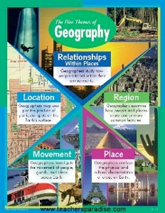
Each of our map lessons is designed to encourage analysis of the “current” situation, and not just a coloring exercise.* Primarily, they reveal two of the five Themes of Geography: Location and Movement.
In addition, I run a separate geography program to teach characteristics of the other three Themes: Place, Region, and Human-Environment Interaction. In other words, some lessons that teach what it’s like there, what one can do there, and how we’ve already affected and been affected by the land.
7th Grade works on United States regional geography (as the nation expands), while 8th Grade focuses on World regional geography (as the nation’s sphere of influence grows).
7th Grade US Regional worksheets (with video programs).
United States United States USA ws.pdf
Northeast USA Northeast USA ws.pdf
Southeast USA Southeast USA ws.pdf
Southwest USA Southwest USA ws.pdf
Midwest USA Midwest USA ws.pdf
the West USA the West USA ws.pdf
U.S. territories
8th Grade World Regional worksheets
I am revising my 8th Grade World Geography program, and will post items here as they are ready.
*I will defend “coloring maps”, however, as a necessary means to learn identification and separation of states and nations, borders and boundaries, features and perspective. Color provides readability, it draws the eye toward the map’s purpose, is more pleasing to the viewer than greyscale, and more easily and appropriately represents physical features. The coloring is not busy-work.